Разделы презентаций
- Разное
- Английский язык
- Астрономия
- Алгебра
- Биология
- География
- Геометрия
- Детские презентации
- Информатика
- История
- Литература
- Математика
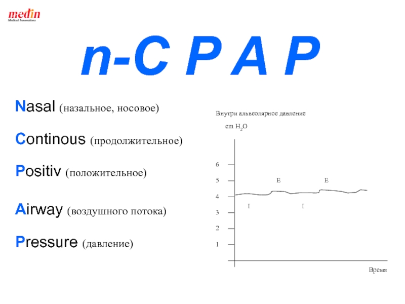
- Медицина
- Менеджмент
- Музыка
- МХК
- Немецкий язык
- ОБЖ
- Обществознание
- Окружающий мир
- Педагогика
- Русский язык
- Технология
- Физика
- Философия
- Химия
- Шаблоны, картинки для презентаций
- Экология
- Экономика
- Юриспруденция
The United Kingdom of Great Britain and Northen Ireland Physical
Содержание
- 1. The United Kingdom of Great Britain and Northen Ireland Physical
- 2. The official name of the country
- 3. Слайд 3
- 4. The Geographical PositionThe United Kingdom of Great
- 5. Seas.The British Isles are washed by the
- 6. The Coastline.The coast-line is greatly indented. There
- 7. The UK is made up of 4
- 8. The Map
- 9. TERRITORYthe United Kingdom’s total - 325,000 sq
- 10. General Information Great Britain and Ireland lie
- 11. Main Islands and Constituent Parts.The largest islands
- 12. The largest part of Ireland is the Irish Republic which doesn't belong to the UK
- 13. The British Isles
- 14. ORKNEYS SHETLANDS
- 15. The Isle of WightSouthern England, in the
- 16. The Isle of WightThe Isle of Wight
- 17. Isles of ScillyThe Isles of Scilly form
- 18. Land's EndLand's End is a small settlement in west Cornwall, England.
- 19. AngleseyAnglesey is an island off the northwest coast of Wales.
- 20. The Isle of ManIsle of Man is
- 21. The Isle of ManThe Isle of Man
- 22. The Channel IslandsThe Channel Islands are a
- 23. The Relief.The relief of Great Britain can
- 24. Highland BritainHighland zone includes Wales, Scotland, and
- 25. Слайд 25
- 26. The PenninesThe Pennines are often called the "backbone of England”.
- 27. The Pennine ChainThe Pennines are a low-rising
- 28. Cheviot HillsCheviot Hills form the part of
- 29. The Cumbrian Mountains To the west of
- 30. The Grampians The Grampian Mountains or
- 31. BEN NEVISBN
- 32. The Highest PeaksBen Nevis – 1,343m, in
- 33. England’s Southwest Peninsula The part of the
- 34. Wales Wales ( in Welsh Cymru) is
- 35. The Cambrian MountainsThe Cambrian Mountains extend roughly
- 36. The Cambrian Mountains and its Highest Peak - Snowdon
- 37. Northern Ireland Northern Ireland is one of
- 38. Northern IrelandNorthern Ireland consists of hilly highlands
- 39. The Mourne Mountains The highest part of
- 40. LakesThe lakes are mostly in Scotland and
- 41. Lough NeaghLoch Neagh is situated in Nortnern
- 42. Loch Lomond – in Scotland
- 43. Loch NessLoch Ness is a large, deep, freshwater lake in the Scottish Highlands
- 44. Loch Ness MonsterThe Loch Ness Monster is
- 45. Searching for the Loch Ness Monster BBC
- 46. Lake DistrictLake District is a region of
- 47. Lowland BritainLowland Britain comprises southern and eastern
- 48. Rivers.
- 49. RIVERSThe most important rivers of England are
- 50. The Thames
- 51. United Kingdom DependenciesBritain’s dependent territories are scattered
- 52. UK DependenciesAnguilla Bermuda British Antarctic Territory British
- 53. The Climate.The geographical position is a basic
- 54. What Influences the Climate?Gulf Stream is a
- 55. The British ClimateA warm ocean current, Gulf
- 56. Union JackThe flag of the UK,
- 57. England The FlagThe
- 58. Scotland The FlagThe white diagonal cross or saltire of St. Andrew on a blue ground (Scotland)
- 59. Wales The Flag
- 60. St Patrick's SaltireSt Patrick's saltire, used by
- 61. Northern Ireland The Flag
- 62. BASIC INFORMATIONThe territory is 244 820 sq
- 63. BRITAIN ON THE MAP OF THE WORLD
- 64. SOME VIEWS OF BRITAIN
- 65. SCOTLAND
- 66. WALES
- 67. NORTHERN IRELAND
- 68. Pennine Chain
- 69. Cumbrian MountainsNorthwest England’s Cumbrian Mountains include Scafell
- 70. View of the Lake DistrictThe Lake District,
- 71. Lake Windermere, Lake District, EnglandWatersports enthusiasts windsurf
- 72. Alum Bay, Isle of WightRegatta at Cowes, Isle of Wight
- 73. Newcastle upon TyneGateshead Millennium BridgeThe Gateshead Millennium
- 74. HullWaterfrontFor centuries the docks at Hull, pictured
- 75. Newcastle upon TyneGateshead Millennium BridgeThe Gateshead Millennium
- 76. Expansive Humber Bridge
- 77. Portsmouth HarborPortsmouth, in southern England, is a
- 78. BristolBristol, located on the Lower Avon River
- 79. Thank You Abrossimova L.S.
- 80. Скачать презентанцию
The official name of the country is The United Kingdom of Great Britain and Northern Ireland
Слайды и текст этой презентации


Слайд 4The Geographical Position
The United Kingdom of Great Britain and Northern
Ireland occupies the territory of the British Isles. The British
Isles are a group of islands lying off the north-west coast of the continent of Europe between the Atlantic Ocean in the north and north-west and the North Sea in the east. They comprise about 5500 islands. Their total area is about 325 sq.km. The UK stretches for over 900 km from south to north
Слайд 5Seas.
The British Isles are washed by the Atlantic Ocean in
the north-west, in the east – by the North Sea.
The islands of Great Britain and Ireland are separated from each other by the Irish Sea, the North Channel and St. George’s Channel. The most important sea routs pass through the English Channel and the North Sea linking Europe with America and other countries.
Слайд 6The Coastline.
The coast-line is greatly indented. There are many bays,
harbours, peninsulas and capes.
Continental Shelf is a submerged edge of
a continent. Continental Shelves surround all the continents. The average depth of a continental shelf is approximately 130m, and the average width is about 65km.
Слайд 7The UK is made up of 4 countries:
England
(London)
Wales (Cardiff)
Scotland (Edinburgh)
Northern Ireland
(Belfast)Wales")

Слайд 9TERRITORY
the United Kingdom’s total - 325,000 sq km
England -
130,410 sq km (50,352 sq mi) (53.4 %)
Scotland - 78,790
sq km (30,420 sq mi) (32.3 %) Wales - 20,760 sq km (8,020 sq mi) (8.5 %)
Northern Ireland - 14,160 sq km (5,470 sq mi) (5.8 %)

Слайд 10General Information
Great Britain and Ireland lie in the north-west
coast of Europe;
Great Britain is separated from the continent by
the English Channel;The country is washed by the waters of the Atlantic Ocean, the North and the Irish Sea.
The British Isles comprise 5500 islands
Total area of British Isles is about 325000 sq. km
The UK stretches for over 900 km from south to north

Слайд 11Main Islands and Constituent Parts.
The largest islands among the British
Isles are Great Britain and Ireland.
England, Wales and Scotland form
Great Britain.Northern Ireland is situated in the north-eastern part of Ireland.


Слайд 13 The British Isles comprise 5500 islands,
including:
The Isle of Man
The Isle of Wight
Scilly Islands
The Hebrides
or Western IslesThe Shetland Islands
The Channel Islands
The Orkney Isles, etc.


Слайд 15The Isle of Wight
Southern England, in the English Channel
Newport is
the administrative center
Area 395 sq. km
A major resort area
Population about
130,000
Слайд 16The Isle of Wight
The Isle of Wight is an English
island and county in the English Channel three miles from
the south coast of Great Britain. It is separated from mainland England by the Solent strait.Popular since Victorian times as a holiday resort, the Isle of Wight is known for its natural beauty and for its world-famous sailing based in Cowes.

Слайд 17Isles of Scilly
The Isles of Scilly form an archipelago of
five inhabited islands and numerous other small rocky islets -
around 140 in total lying 45 km off Land's End.Scilly has been inhabited since the Stone Age. Farming and fishing continue today, but the main industry now is tourism.


Слайд 20The Isle of Man
Isle of Man is in the Irish
Sea, about midway between the coasts of N. Ireland and
EnglandIts area is 572 sq. km and population – about 75000

Слайд 21The Isle of Man
The Isle of Man has its governmental
system. The United Kingdom is responsible for the Island's defence
and for representing the Island at international forums, while the Island's own parliament and government have competence over all domestic matters.The island is famous for the Manx cat, characterized by the absense of a tail.

Слайд 22The Channel Islands
The Channel Islands are a group of islands
in the English Channel, off the French coast of Normandy.
The islands are governed by representatives of the British monarch, and each has a constitution and elected government
Tourism is the major industry in the smaller islands (with some agriculture).
French and English are the official languages.

Слайд 23The Relief.
The relief of Great Britain can be divided into
two major natural regions – the highland zone and the
lowland zone. The highland zone is an area of high hills and mountains in the north and west. The lowland zone in the south and east consists mostly of rolling plains.
Слайд 24Highland Britain
Highland zone includes Wales, Scotland, and parts of England.
All mountains are not very high. The mountains and hills
consist mainly of old, hard rocks.The parts of England include the Pennine Chain, the Cumbrian Mountains, in Scotland – Grampian Mountains, in Wales – the Cambrian Mountains.
The highland zone is cooler than the lowland zone, and receives more rainfall and less sunlight.


Слайд 27The Pennine Chain
The Pennines are a low-rising mountain range in
northern England and southern Scotland.
The mountains are not very
high and are often referred to as fells. The highest peak is Cross Felll in eastern Cumbria, at 2,930 feet (893 m) 
Слайд 28Cheviot Hills
Cheviot Hills form the part of the boundary between
England and Scotland, extending 56km in a northeastern – southwestern
direction. The highest point is Cheviot, or Cheviot Hill.
Слайд 29The Cumbrian Mountains
To the west of the northern
Pennines are the Cumbrian Mountains, which include Scafell Pike (in
the Lake District, Cumberland) 3,210 feet (978 meters), England’s highest peak. This region contains the Lake District, famous for its lakes and scenic beauty.
Слайд 30The Grampians
The Grampian Mountains or Grampians are one
of the three major mountain ranges in Scotland. They form
a natural division between the Lowlands and Highlands of Scotland.

Слайд 32The Highest Peaks
Ben Nevis – 1,343m, in the Grampian Mountains
(Scotland).
Y Wyddfa – 1,085m, in Snowdon (Wales).
Scafell Pike – 978m,
in the Cumbrian Mountains (England)..Y")
Слайд 33England’s Southwest Peninsula
The part of the highland zone in
England’s southwest peninsula is often referred to as the West
Country. This peninsula, which juts out into the Atlantic Ocean, contains the counties of Devon and Cornwall. Its sheltered areas are noted for their mild climate.
Слайд 34Wales
Wales ( in Welsh Cymru) is a country that
is part of the United Kingdom and the island of
Great Britain, bordered by England to its east and the Atlantic Ocean and Irish Sea to its west. It has a population of three million. The peninsula of Wales is almost entirely covered by mountains. is a country that is")
Слайд 35The Cambrian Mountains
The Cambrian Mountains extend roughly from northeast to
southeast across the peninsula.
They contain the highest peak in
Wales, the huge mountain called Snowdon (Yr Wyddfa Fawr in Welsh - 1,085 m.The lowland region of southeastern Wales contains the largest cities in Wales: Cardiff, Swansea and Newport


Слайд 37Northern Ireland
Northern Ireland is one of the four countries
of the United Kingdom. Situated in the north-east of the
island of Ireland, it shares a border with the Republic of Ireland to the south and west. At the time of the 2001 UK Census, its population was 1,685,000, constituting about 3% of the population of the United Kingdom.
Слайд 38Northern Ireland
Northern Ireland consists of hilly highlands similar to those
of Scotland.
Most of Northern Ireland is situated in a
large valley formed from an old lava plateau. 
Слайд 39The Mourne Mountains
The highest part of Northern Ireland is
the Mourne Mountains in the southeast, which reach a maximum
elevation of 852 m (2,796 ft) above sea level.
Слайд 40Lakes
The lakes are mostly in Scotland and north-west England
They are
usually too small and too remote
The largest is Lough Neagh
in Northern Ireland (29 km long and 24 km wide)The lakes of Scotland and those of the Lake District (Windermere Lake (1.6 km wide and 16 km long) in the north-west of England are attractive to tourists

Слайд 41Lough Neagh
Loch Neagh is situated in Nortnern Ireland. It is
the largest freshwater lake in the UK, which is 29
km long and 24 km wide.


Слайд 44Loch Ness Monster
The Loch Ness Monster is a debated, mythical
creature, most commonly speculated to be from a line of
long-surviving plesiosaurs that is reputed to inhabit Loch Ness in the Scottish Highlands.
Слайд 45Searching for the Loch Ness Monster BBC (2003)
2003, the BBC
sponsored a full search of the Loch using 600 separate
sonar beams and satellite tracking. No animal of any substantial size was found whatsoever and despite high hopes, the scientists involved in the expedition admitted that this essentially proved the Loch Ness monster was only a myth.2003, the BBC sponsored")
Слайд 46Lake District
Lake District is a region of mountains and lakes
in northeastern England. There are several lakes, innumerable mountain streams.
The district extends about 50km from north to south and about 40km from east to west. Lake District attracts crowds of tourists.It became famous when a group of British poets (including William Wordsworth, Samuel Taylor Coleridge, and Robert Southey) made it their home about the beginning of the 19th century.

Слайд 47Lowland Britain
Lowland Britain comprises southern and eastern Britain
It receives less
rain and more sunshine than the highland zone and much
of the soil in the zone is fertile.

Слайд 49RIVERS
The most important rivers of England are the Severn (354
km) and the Thames on which London stands.
The chief rivers
of Scotland are the Tay (188 km) and the Clyde (170 km)The most important rivers in Northern Ireland are the Lagan, the Bann, and the Foyle.
The longest river in the British Isles, the Shannon (386 km) is in Ireland
")

Слайд 51United Kingdom Dependencies
Britain’s dependent territories are scattered throughout the world
and are the remains of the former British Empire.
The
dependencies, located close to Britain, are the Isle of Man in the Irish Sea and the Channel Islands off the northern coast of France. 
Слайд 52UK Dependencies
Anguilla
Bermuda
British Antarctic Territory
British Indian Ocean Territory
British Virgin Islands
Cayman Islands
Falkland Islands (Islas Malvinas)
Gibraltar
Montserrat
Pitcairn Island
Saint Helena
South Georgia Islands
South Sandwich Islands
Turks and Caicos Islands

Слайд 53The Climate.
The geographical position is a basic factor in determining
the main characteristics of the climate.
Britain has a generally mild
and temperate climate. The outstanding features of the climate of Britain are its humidity, its mildness and its variability. 
Слайд 54What Influences the Climate?
Gulf Stream is a warm current of
the North Atlantic Ocean.
Prevailing southwesterly winds moving across this warmer
water bring moisture and moderating temperatures to the British Isles.
Слайд 55The British Climate
A warm ocean current, Gulf Stream, washes Britain’s
western shores. This water heats up and cools down very
slowlyBritain enjoys warmer winters and cooler summers than other countries at the same latitude
The west of the island has a higher rainfall and slightly milder climate than the east
In general, temperatures are ordinarily around 15’C in the summer and around 5’C in the winter. Temperature rarely ever exceed 32 degrees C or drop below -10 degrees C anywhere in the British Isles. In general, frost, when the temperature dips below 0 degrees C, is rare.
Average annual precipitation is more than 1,000 mm, varying from the extremes of 5,000 mm in the western Highlands of Scotland to less than 500 mm in the driest parts east Anglia in England.

Слайд 56 Union Jack
The flag of the UK, known as the
Union Jack is made up of three crosses
The red cross
of St. George on a white ground (for England)The white diagonal cross or saltire of St. Andrew on a blue ground (Scotland)
The red saltire of St. Patric on a white ground (Ireland)


Слайд 58Scotland
The Flag
The white diagonal cross or saltire of St. Andrew
on a blue ground (Scotland)
")

Слайд 60St Patrick's Saltire
St Patrick's saltire, used by some Irish organizations
and institutions and incorporated into the Union Flag.
After the
1800 Act of Union joined Ireland with the Kingdom of Great Britain, the saltire was added to the British flag to form the Union Jack still used by the United Kingdom. Saint Patrick's Cross is rejected by Irish nationalists as a British invention. 

Слайд 62BASIC INFORMATION
The territory is 244 820 sq km.
Administrative division: 47
counties, 7 capital counties, 26 regions, 9 areas, 3 island
regions.The capital is London.
The biggest cities are London (the population - 7,640,000), Birmingham (2,270,000), Manchester (2,250,000), Glasgow (680,000).
The population is about 61 mln
The national structure: the English - 81,5%, the Scottish - 9,6%, the Irish - 2,4%, the Welsh - 1.9%, immigrants from West-India, India, Pakistan and others - 2,8%.
The languages: English (official), Welsh (is spoken by quarter of the population of Wales), Scottish Gaelic (about 60,000 in Scotland).
Religion: Anglican – 27 mln., Roman Catholic – 9 mln., Muslim – 1 mln., Methodists – 760,000, Hindu – 350,000, Judaism – 300,000
Form of government: constitutional monarchy
The head of the state: Queen Elizabeth II
The head of the Government: Prime-Minister David Cameron
Conservative Party Leader - David Cameron


Слайд 69Cumbrian Mountains
Northwest England’s Cumbrian Mountains include Scafell Pike, the country’s
highest peak. The range also incorporates the Lake District, an
area of rivers and lakes which became famous when several British poets, including William Wordsworth, settled there in the early 1800s.
Слайд 70View of the Lake District
The Lake District, in England's northwestern
corner, includes some of the country's most beautiful and varied
landscapes. Located in the county of Cumbria, the area has, since the 18th century, attracted romantic poets such as William Wordsworth, who hoped to capture the rugged appeal of its deep blue lakes, rocky peaks, rolling green pastures, and isolated villages. The Lake District's Scafell Pike is England's highest mountain, at 978 m (3,209 ft) above sea level.
Слайд 71Lake Windermere, Lake District, England
Watersports enthusiasts windsurf on Lake Windermere
in England’s Lake District. Windermere has become a popular venue
for watersports and fishing, leading to conflicts with conservationists over the use of the area.

Слайд 73Newcastle upon Tyne
Gateshead Millennium Bridge
The Gateshead Millennium Bridge, popularly called
the "Blinking Eye," is a unique tilting bridge linking the
communities of Newcastle upon Tyne and Gateshead in northeastern England. The pedestrian and cycle bridge lifts like a giant eyelid to enable ships to pass beneath. In its raised position the bridge resembles the steel arch of the famous Tyne Bridge, visible in the background. A multicolored lighting system illuminates the bridge, which opened in 2001.
Слайд 74Hull
Waterfront
For centuries the docks at Hull, pictured here, were part
of Britain’s main fishing port. However, in the 1970s the
harbor at nearby Grimsby was improved and expanded, and Grimsby became the country’s principal fishing port.
Слайд 75Newcastle upon Tyne
Gateshead Millennium Bridge
The Gateshead Millennium Bridge, popularly called
the "Blinking Eye," is a unique tilting bridge linking the
communities of Newcastle upon Tyne and Gateshead in northeastern England. The pedestrian and cycle bridge lifts like a giant eyelid to enable ships to pass beneath. In its raised position the bridge resembles the steel arch of the famous Tyne Bridge, visible in the background. A multicolored lighting system illuminates the bridge, which opened in 2001.

Слайд 77Portsmouth Harbor
Portsmouth, in southern England, is a transportation center and
home to one of the United Kingdom’s most important naval
dockyards. The city’s sheltered harbor has made it an important port for centuries. The South sea section of the city is a popular seaside resort.
Слайд 78Bristol
Bristol, located on the Lower Avon River in England, has
been a thriving port city since the 10th century. The
old docks are now being carefully restored and transformed into arts and recreation centers.